プロジェクト
プロジェクト
受賞カテゴリ
地理空間とリアリティモデリング
場所
シンガポール
使用されるBentleyソフトウェア
ContextCapture、Orbit 3DM
プロジェクト概要
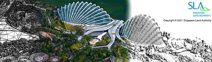
シンガポール土地管理局は、2014/2015年の全国3Dマップを更新し、政府機関や利害関係者に向けてより高い精度とアクセス性を実現するため、3Dリアリティマッピングプロジェクトを開始しました。160,000万枚以上の高解像度画像から成る720キロメートルの領域をカバーしなくてはならないため、データ処理の課題に加えて、さまざまなレガシーシステムを使用する多数の機関の間でのデータ相互運用性の問題にも対処しなくてはなりませんでした。サードパーティのソフトウェアアプリケーションを検討しましたが、クラウドベースのデジタルツインを提供するには、包括的で相互運用可能なリアリティモデリングおよびマッピングソリューションが必要でした。同機関はContextCaptureによって0.1mの精度で全土のリアリティメッシュを生成し、シンガポールのすべての公道を網羅した25テラバイト以上のデータをOrbit 3DMによって組み込みました。そして、全国の多様なインフラプロジェクトに利用できる持続可能なデジタルツインを作成しました。Bentleyのテクノロジにより、従来の方法と比較して、2900万シンガポールドルを節約し、期間を1年4か月短縮しながら、動的な全国規模の3Dリアリティメッシュを生成して、ユーザーのアクセス性を60%向上しました。このプロジェクトは、シンガポールのデジタルトランスフォーメーションと発展を促進するものとなっています。
