프로젝트
프로젝트
수상 부문
지리 공간 및 현실 모델링
위치
싱가포르
사용된 Bentley 소프트웨어
ContextCapture, Orbit 3DM
프로젝트 개요
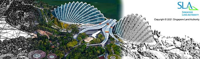
싱가포르 국토청은 정부 기관 및 이해관계자들에게 정확성과 접근성을 개선하기 위해 2014/2015 국가 3D 지도를 업데이트하는 3D 현실 매핑 프로젝트를 시작하였습니다. 본 프로젝트는 160,000개 이상의 고해상도 이미지로 구성되어 있는 720km 영역의 거대한 규모를 대상으로 하여, 다양한 레거시 시스템을 활용하는 여러 기관 간의 데이터 상호 운용성 문제로 인한 데이터 처리 과제가 도출되었습니다. 그들은 서드 파티 소프트웨어 애플리케이션을 탐색하였지만 클라우드 기반의 디지털 트윈을 제공할 수 있는 포괄적이고, 상호 운용 가능한 현실 모델링 및 매핑 솔루션이 필요했습니다. 그들은 싱가포르 모든 공공 도로의 25TB 이상의 데이터를 통합할 수 있도록 0.1m 수준의 정확도를 보이는 전국 현실 메시 및 Orbit 3DM을 생성하기 위하여 ContextCapture을 선택하였으며, 이로 인해 다양한 국가 인프라 프로젝트에 지속 가능한 디지털을 구축할 수 있었습니다. 기존 방식과 비교했을 때 Bentley 기술은 2,900만 싱가포르 달러(SGD)를 절감하고 1년 4개월의 기간을 단축했으며, 동적인 국가 단위의 3D 현실 메시를 생성하고 사용자 접근성을 60% 향상했습니다. 이 프로젝트는 싱가포르의 디지털 혁신과 개발을 촉진합니다.
