Project
Singapore Land Authority
Advancing Singapore National 3D Reality Mapping for Changing World
Project
Singapore Land Authority
Advancing Singapore National 3D Reality Mapping for Changing World
Geospatial and reality modeling
Singapore
Bentley software used
ContextCapture, Orbit 3DM
Project summary
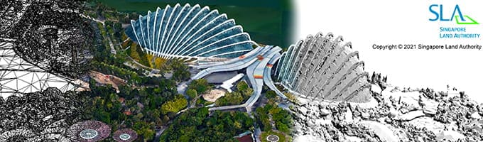
Singapore Land Authority initiated a 3D reality mapping project to update its 2014/2015 national 3D map, improving accuracy and accessibility to government agencies and stakeholders. Covering a 720-kilometer area consisting of over 160,000 high-resolution images, the scale presented data processing challenges compounded by data interoperability difficulties among numerous agencies using varying legacy systems. They explored third-party software applications, but needed a comprehensive, interoperable reality modeling and mapping solution to deliver a cloud-based digital twin.
They selected ContextCapture to generate a 0.1-meter accurate nationwide reality mesh and Orbit 3DM to incorporate over 25 terabytes of data covering all public roads in Singapore, resulting in a sustainable digital twin for a variety of nationwide infrastructure projects. Compared to traditional methods, Bentley technology saved SGD 29 million and one year and four months, generating a dynamic, national 3D reality mesh while increasing user accessibility by 60%. The project promotes digital transformation and development of Singapore.
