Project
Aurecon
Digitizing urban ground: Transforming subsurface engineering
Project
Aurecon
Digitizing urban ground: Transforming subsurface engineering
User Success
Auckland, New Zealand
Bentley software used
Leapfrog, OpenGround, Seequent Central
Project summary
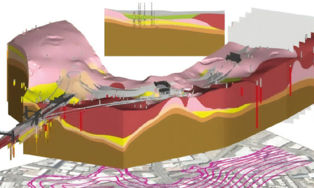
This urban digitization initiative in Auckland aims to change infrastructure planning using comprehensive 3D visualization to better understand subsurface conditions. Aurecon is developing the digital strategy and faced challenges integrating decades of historical unstructured data compounded by Auckland’s complex subsurface environment. They sought to develop interactive 3D geological models that are scalable and reusable, supporting design of major assets across the globe, but recognized that traditional static geotechnical solutions lacked necessary modeling, scalability, and collaborative capabilities.
Leveraging Leapfrog, Seequent Central, and OpenGround, Aurecon created a digital twin of Auckland’s central business district built on more than 8,000 geotechnical data points and supported by a collaborative digital ecosystem for integrated city-wide workflows. Working in a connected geotechnical data environment reduced early-stage planning and design by at least 20%, saved 15% in costs during project feasibility stages, and cut cross-team coordination time by 30% to 50%. The digital twin redefines subsurface engineering, supports environmental sustainability and cultural planning, and offers multicity scalability, promoting smart city initiatives.
